Village Data Analytics
Zwei Milliarden Menschen sind von jedem Stromnetz abgeschnitten. Sie leben mit behelfsmäßigen Generatoren oder ganz ohne Strom. Dies ist eine enorme Herausforderung, insbesondere für die Gesundheitsversorgung in Zeiten einer globalen Pandemie: 600 Millionen Menschen werden von Gesundheitszentren versorgt, die nicht über den notwendigen Strom verfügen, um elektronische medizinische Geräte aufzuladen, eine Internetverbindung für Kommunikation und Information herzustellen oder Kühlgeräte für die Lagerung von Medikamenten und Impfstoffen zu betreiben. Die Verbesserung dieser Situation und die Bereitstellung eines erschwinglichen und nachhaltigen Zugangs zu Energie ist nicht nur die Aufgabe von Village Data Analytics, sondern auch eines der Ziele für nachhaltige Entwicklung der Vereinten Nationen.
Datenarme Märkte hemmen Investitionen
Vor allem Entwicklungsländer sind von diesem Mangel an Infrastruktur betroffen. Entwicklungsorganisationen, NGOs und Unternehmen versuchen seit Jahren, Abhilfe zu schaffen, allerdings mit mäßigem Erfolg. Das Problem ist nicht ein Mangel an Ideen, sondern ein Mangel an zuverlässigen Daten. Investitionen können nicht angemessen geplant werden und die Auswirkungen von Hilfsprojekten in ländlichen Dörfern lassen sich nicht messen, da die Daten meist unvollständig, nicht vorhanden oder veraltet sind.
Im Gegensatz zu den datengesättigten Volkswirtschaften gibt es in den Entwicklungsländern nicht genügend zuverlässige Entscheidungsinformationen in Echtzeit, um Investitionen sinnvoll zu gestalten. In datenarmen Märkten wissen die Regierungen oft nicht, wo sich Dörfer befinden, wie viele Menschen dort leben, wo ihr Stromnetz verläuft, wo sich Gesundheitszentren befinden und wo die Menschen funktionierende Gesundheitszentren benötigen. Sie können keine optimalen Investitionen in die ländliche Gesundheitsinfrastruktur auf der Grundlage der Bedürfnisse der Dörfer planen. So werden Milliarden verschwendet, ohne dass das Leben der Menschen verbessert wird.
Satelliten als Datenquelle
Derzeit muss man sich persönlich dorthin begeben, um die Lage von Dörfern, die Bevölkerungszahl oder die Versorgungsdichte zu identifizieren. Das Sammeln von verwertbaren Daten ist mit großem Aufwand verbunden. Im Rahmen kleinerer Hilfsprojekte ist das noch möglich - zwei Milliarden Menschen kann jedoch niemand persönlich befragen.
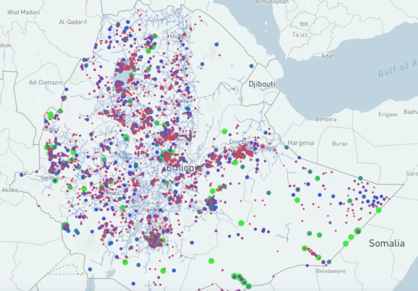
Projekte wie Village Data Analytics, kurz VIDA, sammeln daher Satellitendaten, um die Informationslücken zu schließen. KI-basierte Algorithmen analysieren dazu Satellitenbilder und Daten vor Ort, um Versorgungslücken aufzudecken, Karten zu vervollständigen und die kürzesten Wege aufzuzeigen. Planer und Elektrifizierungsunternehmen können so gezielt in die Elektrifizierung von Gesundheitszentren investieren.
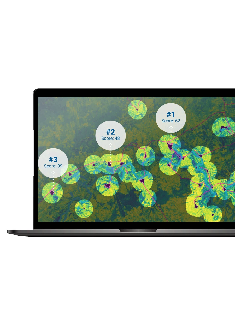
Regierungen, Unternehmen und Investoren können dadurch erfahren, wo sie strategisch und effektiv ansetzen können, um so vielen Menschen wie möglich zu helfen. Ein konkretes Beispiel ist das Projekt "VIDA vs. COVID", das Gesundheitszentren ohne Zugang zum Stromnetz identifiziert und Kennzahlen wie Fahrtzeit, versorgte Bevölkerung, Dienstleistungsniveau und Zugang zur Infrastruktur berechnet. Die Ergebnisse werden in einem großen, vom Kunden ausgewählten Gebiet auf einer interaktiven Karte angezeigt.
Maschinelles Lernen und lokale Validierung
Um robuste Daten aus Satellitenbildern zu erhalten, werden maschinelles Lernen und selbstoptimierende Algorithmen eingesetzt. Diese werten zum Beispiel nächtliche Satellitenbilder der NASA aus und verwenden ein Modell zur Vorhersage des kürzesten Weges, um zu prüfen, ob das Gesundheitszentrum bereits an das nationale Stromnetz angeschlossen ist. Ein anderer Algorithmus identifiziert die Ausdehnung und die Merkmale von Siedlungen in der Nähe von Gesundheitseinrichtungen anhand von Tageslicht-Satellitenbildern des Sentinel-2-Sensors der ESA. Die Software extrahiert Merkmale wie die Größe und Dichte von Siedlungen, Lage und zeitliche Merkmale von Gewässern in der Nähe, Straßenzugang und landwirtschaftliche Nutzung.
Satellitenbilder, die über Jahre oder Jahrzehnte hinweg aufgenommen wurden, können für die Zeitreihenanalyse verwendet werden. Auf diese Weise lässt sich die Geschichte jeder Siedlung nachverfolgen und es können Vorhersagemodelle erstellt werden: Wie stark wird ein Dorf in den kommenden Jahren wachsen? Wie stark wird sich seine Wirtschaftsleistung verändern? Diese Fragen können anhand der gewonnenen Daten modelliert werden.
Die Ergebnisse stammen jedoch nicht allein aus den Berechnungen der Algorithmen. Umfragen und Datenerhebungen vor Ort sowie Datenströme von IoT-Geräten, die bereits in bestehenden Mini-Netzen eingesetzt werden (intelligente Zähler), werden zur Validierung verwendet. Diese Daten stammen oft von Regierungen und Unternehmen selbst. Auch die Weltbank stellt Datensätze zur Verfügung, die für eine detaillierte Datenanalyse benötigt werden.
Wie IBM VIDA bei der Arbeit mit großen Erdbeobachtungsdatensätzen half
Ein Anwendungsfall, bei dem eine riesige Menge an Daten verarbeitet werden muss, um ein neuronales Netz zu trainieren, ist die Identifizierung von Gewässern anhand von Satellitenbildern. Die Entfernung eines Dorfes zu einem Gewässer und seine jahreszeitlichen Veränderungen in Form und Volumen sind wichtige Faktoren für strategische Entscheidungen zur Elektrifizierung. Es gibt herkömmliche Ansätze zum Auffinden von Gewässern in Satellitenbildern, die die von den Sensoren gelieferten Nahinfrarotdaten nutzen. Im Vergleich zu modernen Lösungen des maschinellen Lernens sind sie jedoch weniger leistungsfähig.
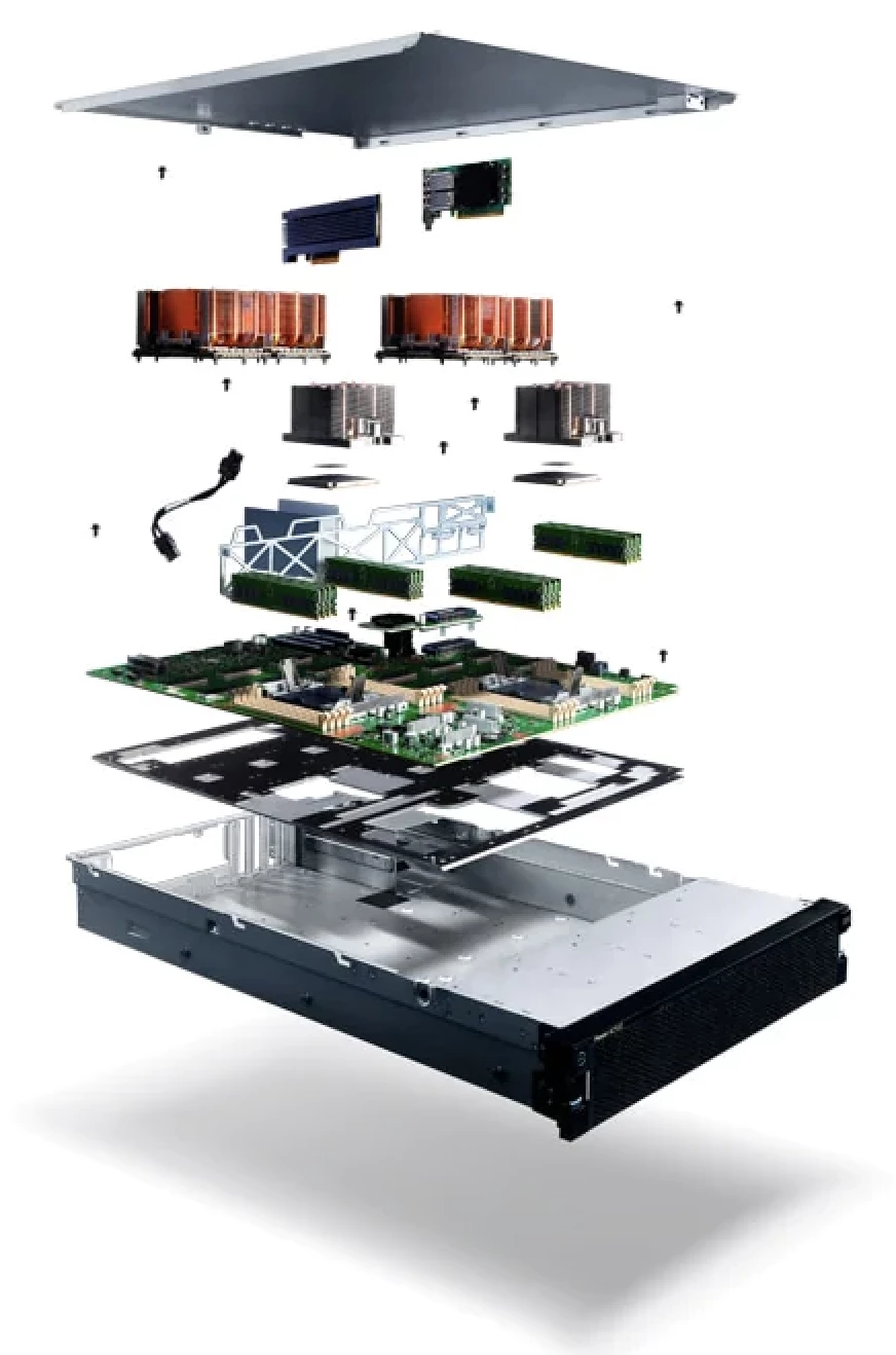
Die ursprünglichen Trainingsdaten für den Deep-Learning-Algorithmus Deepwatermap sind etwa 1 Terabyte groß und übersteigen damit die Möglichkeiten der meisten Computer für das (Neu-)Training des Erkennungsmodells. Die IBM® Power System™ AC922Server und das Watson Machine LearningToolkit sind jedoch perfekt für die Verarbeitung dieser massiven Datensätze ausgestattet und können zum effizienten Training solcher neuronaler Netze verwendet werden. Der AC922 bietet eine beispiellose Leistung für Analytik, Künstliche Intelligenz und modernes HPC. Die AC922 ist in der Lage, flexible Modelle einzusetzen, verfügt über offene Frameworks und umfasst Software-Tools innerhalb eines geschlossenen Ökosystems. Auf der Softwareseite unterstützt Watson Machine Learning(WML) die Projekte und bietet eine breite Palette von Tools und Dienstleistungen. WML automatisiert den Trainingsprozess für Rapid Prototyping vollständig und bietet Tools, die eine vollständige Kontrolle über die Erstellung eines Modells ermöglichen, das für Machine Learning-Modelle geeignet ist. Das leistungsstarke System aus Software und Infrastruktur ermöglicht es VIDA, das maschinelle Lernmodell von Grund auf neu zu trainieren und neu verfügbare Satellitenbilder oder Bodenwahrheitsdaten einzubeziehen.
Erfolgsfaktoren: Erfahrung und Technologie
Der Erfolg von "VIDA vs. COVID" besteht darin, den Zugang der ländlichen Bevölkerung in Afrika südlich der Sahara zu einer funktionierenden Gesundheitsversorgung zu verbessern und damit die Widerstandsfähigkeit dieser Länder gegenüber der COVID-Pandemie und anderen Gesundheitsrisiken zu erhöhen. Derzeit sind bis zu 80 Prozent der ländlichen Gesundheitseinrichtungen nicht elektrifiziert. Da es sich um eine strategische Maßnahme handelt, kann sie Hunderten von Millionen Menschen den Zugang zu Strom und Gesundheitsversorgung ermöglichen.
Die Technologie allein kann jedoch nicht den erforderlichen Erfolg bringen. Ein Team von Experten ist in jedem Anwendungsfall wichtig und der Einsatz in und für Entwicklungsländer erfordert eine besondere Kombination aus lokaler Erfahrung, Marktkenntnis sowie technischem Fachwissen. Die Aufrechterhaltung eines Teams vor Ort ist von entscheidender Bedeutung: Nur vor Ort wird klar, welche Parameter wichtig sind, und nur vor Ort können die gefundenen Lösungen angewendet und getestet werden.
Das digitale Grundgerüst
Konkret helfen solche Projekte zum Beispiel, ganze Regionen zu elektrifizieren. Das ist die wichtige und notwendige Voraussetzung für den nächsten Schritt: die Digitalisierung. Menschen und Märkte, die vom Stromnetz abgeschnitten sind, haben keinen Zugang zum globalisierten, digitalen Markt und fallen hinter andere zurück.
Eine weitere wichtige Anwendung ist die optimale Platzierung von Infrastrukturen wie z.B. Funktürmen. Auch beim Bau von Schulen oder Krankenhäusern lassen sich mögliche Standorte besser bestimmen, um möglichst viele Menschen zu erreichen. Darüber hinaus bieten die Daten auch Einzelhändlern eine zuverlässige Informationsquelle über die bisher unzureichend kartierten Gebiete, in denen sie Produkte wie Solaranlagen, Wasserpumpen oder landwirtschaftliche Geräte anbieten können.
In unserer Informationsgesellschaft wird der Standort immer mehr zu einem sekundären Faktor. Hier bietet die Digitalisierung die Chance, den globalen Markt mit Lösungen und Dienstleistungen zu bedienen - und den lokalen Markt mit digitalisierten Dienstleistungen effizient zu fördern. So entsteht ein digitales Rückgrat für Gebiete, die bisher von der Digitalisierung abgeschottet waren. Diese Errungenschaft ist auf lange Sicht von entscheidender Bedeutung und bietet eine enorme Chance für Entwicklungsländer.